
Bietenhorn topographic map
Interactive map
Click on the map to display elevation.
About this map
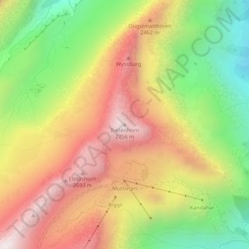
Name: Bietenhorn topographic map, elevation, terrain.
Average elevation: 2,250 m
Minimum elevation: 1,714 m
Maximum elevation: 2,763 m
Other topographic maps
Click on a map to view its topography, its elevation and its terrain.
Jungfraujoch
Suiza > Berna > Verwaltungskreis Interlaken-Oberhasli > Lauterbrunnen
Jungfraujoch, Lauterbrunnen, Verwaltungskreis Interlaken-Oberhasli, Verwaltungsregion Oberland, Berna, 3801, Suiza
Average elevation: 3,307 m
Jungfrau
Suiza > Berna > Verwaltungskreis Interlaken-Oberhasli > Lauterbrunnen
Jungfrau, Lauterbrunnen, Verwaltungskreis Interlaken-Oberhasli, Verwaltungsregion Oberland, Berna, 3801, Suiza
Average elevation: 3,401 m