
Make a donation
Gear up for your next adventure:
As an Amazon Associate, this site earns from qualifying purchases at no extra cost to you.
Napa Valley AVA topographic map
Click on the map to display elevation.
Make a donation
Gear up for your next adventure:
As an Amazon Associate, this site earns from qualifying purchases at no extra cost to you.
Napa Valley AVA
Napa Valley's climate and geography are shaped by a unique cooling effect, crucial for premium grape growing. Originating from a cold ocean current from Alaska, this effect involves fog formation and cool air influx from the Pacific, offset by warmer air rising from California's Central Valley. This dynamic results in a climate system where fog and cooler sea air are drawn inland through valleys, create ideal conditions for high-quality viticulture. The region's complexity extends to varying topography, sun exposure, and diverse soils, contributing to a wide array of microclimates or terroirs within a relatively small viticulture area. Napa Valley, despite its linear appearance, is a tapestry of climate influences from the adjacent Vaca and Mayacamas mountain ranges, alongside varied lithologies influencing vineyard substrates. This geographical diversity, coupled with the Mediterranean climate characterized by hot, dry summers and cool, wet winters, impacts grape growing in the Napa Valley. Rainfall distribution and the daily summer fog, which typically shrouds the valley until mid-morning, vary across the region, affecting grape variety and quality. However, the potential impacts of climate change pose new challenges: rising global temperatures and possible disruptions to the cooling effect could alter the conditions that have historically favored premium grape growing in Napa Valley.
Make a donation
Gear up for your next adventure:
As an Amazon Associate, this site earns from qualifying purchases at no extra cost to you.
About this map
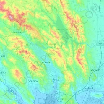
Name: Napa Valley AVA topographic map, elevation, terrain.
Location: Napa Valley AVA, Napa County, California, United States (38.15486 -122.64681 38.76831 -122.06139)
Average elevation: 222 m
Minimum elevation: -4 m
Maximum elevation: 1,284 m
Make a donation
Gear up for your next adventure:
As an Amazon Associate, this site earns from qualifying purchases at no extra cost to you.
Other topographic maps
Click on a map to view its topography, its elevation and its terrain.
Make a donation
Gear up for your next adventure:
As an Amazon Associate, this site earns from qualifying purchases at no extra cost to you.
Make a donation
Gear up for your next adventure:
As an Amazon Associate, this site earns from qualifying purchases at no extra cost to you.
Make a donation
Gear up for your next adventure:
As an Amazon Associate, this site earns from qualifying purchases at no extra cost to you.
Make a donation
Gear up for your next adventure:
As an Amazon Associate, this site earns from qualifying purchases at no extra cost to you.