
Make a donation
Gear up for your next adventure:
As an Amazon Associate, this site earns from qualifying purchases at no extra cost to you.
Lijiang City topographic map
Click on the map to display elevation.
Make a donation
Gear up for your next adventure:
As an Amazon Associate, this site earns from qualifying purchases at no extra cost to you.
About this map
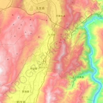
Name: Lijiang City topographic map, elevation, terrain.
Location: Qihe, Gucheng District, Lijiang City, Yunnan, China (26.60587 100.07938 26.80115 100.40294)
Average elevation: 2,529 m
Minimum elevation: 1,230 m
Maximum elevation: 3,636 m
Make a donation
Gear up for your next adventure:
As an Amazon Associate, this site earns from qualifying purchases at no extra cost to you.
Other topographic maps
Click on a map to view its topography, its elevation and its terrain.
Jade Dragon Snow Mountain
China > Yunnan > Lijiang City
The view of the massif from the gardens at the Black Dragon Pool (Heilong Tan) in Lijiang is noted as one of China's finest views. The mountain is part of Yulong Snow Mountain National Scenic Area and National Geological Park, an AAAAA-classified scenic area. The Park operates a tourist cable car that climbs…
Average elevation: 4,829 m