
Étang Sale topographic map
Interactive map
Click on the map to display elevation.
About this map
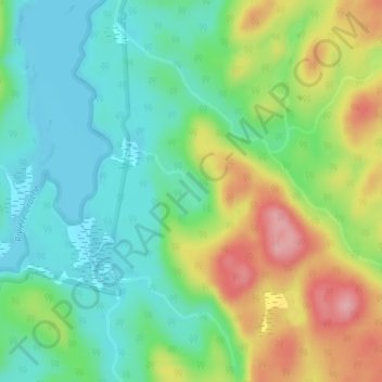
Name: Étang Sale topographic map, elevation, terrain.
Average elevation: 410 m
Minimum elevation: 356 m
Maximum elevation: 507 m
Other topographic maps
Click on a map to view its topography, its elevation and its terrain.
Lac des Hermines
Canada > Québec > Lac-Ashuapmushuan
Lac des Hermines, Lac-Ashuapmushuan, Le Domaine-du-Roy, Saguenay–Lac-Saint-Jean, Québec, Canada
Average elevation: 449 m
Lac-Ashuapmushuan
Canada > Québec > Lac-Ashuapmushuan
Lac-Ashuapmushuan, Le Domaine-du-Roy, Saguenay–Lac-Saint-Jean, Québec, Canada
Average elevation: 415 m
Lac Lancelot
Canada > Québec > Lac-Ashuapmushuan
Lac Lancelot, Lac-Ashuapmushuan, Le Domaine-du-Roy, Saguenay - Lac-Saint-Jean, Québec, Canada
Average elevation: 564 m
Lac Fictif
Canada > Québec > Lac-Ashuapmushuan
Lac Fictif, Lac-Ashuapmushuan, Le Domaine-du-Roy, Saguenay - Lac-Saint-Jean, Québec, Canada
Average elevation: 574 m
Rivière Chaudière
Canada > Québec > Lac-Ashuapmushuan
Rivière Chaudière, Lac-Ashuapmushuan, Le Domaine-du-Roy, Saguenay - Lac-Saint-Jean, Québec, Canada
Average elevation: 421 m
Lac Avril
Canada > Québec > Lac-Ashuapmushuan
Lac Avril, Chemin Consolidated, Lac-Ashuapmushuan, Le Domaine-du-Roy, Saguenay - Lac-Saint-Jean, Québec, Canada
Average elevation: 509 m
Lac Volta
Canada > Québec > Lac-Ashuapmushuan
Lac Volta, Lac-Ashuapmushuan, Le Domaine-du-Roy, Saguenay - Lac-Saint-Jean, Québec, Canada
Average elevation: 427 m