
จังหวัดประจวบคีรีขันธ์ topographic map
Interactive map
Click on the map to display elevation.
About this map
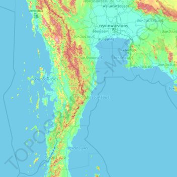
Name: จังหวัดประจวบคีรีขันธ์ topographic map, elevation, terrain.
Location: จังหวัดประจวบคีรีขันธ์, Thailand (9.48327 97.18872 14.60327 102.30872)
Average elevation: 68 m
Minimum elevation: -3 m
Maximum elevation: 1,633 m
Other topographic maps
Click on a map to view its topography, its elevation and its terrain.
Nationalpark Khao Sam Roi Yot
Thailand > จังหวัดประจวบคีรีขันธ์ > บ้านหุบตาโคตร
Nationalpark Khao Sam Roi Yot, สามร้อยยอด 22, บ้านหุบตาโคตร, จังหวัดประจวบคีรีขันธ์, Thailand
Average elevation: 23 m