
Gattendorf topographic map
Interactive map
Click on the map to display elevation.
About this map
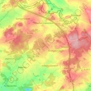
Name: Gattendorf topographic map, elevation, terrain.
Average elevation: 547 m
Minimum elevation: 463 m
Maximum elevation: 605 m
Other topographic maps
Click on a map to view its topography, its elevation and its terrain.
95213
Germany > Bavaria > Landkreis Hof > Münchberg > Poppenreuth > Obereinzel
Average elevation: 583 m