
Pilsheim topographic map
Interactive map
Click on the map to display elevation.
About this map
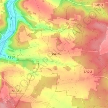
Name: Pilsheim topographic map, elevation, terrain.
Average elevation: 422 m
Minimum elevation: 354 m
Maximum elevation: 462 m
Other topographic maps
Click on a map to view its topography, its elevation and its terrain.
Pottenstetten
Deutschland > Bayern > Landkreis Schwandorf > Burglengenfeld
Pottenstetten, Burglengenfeld, Landkreis Schwandorf, Bayern, 93133, Deutschland
Average elevation: 426 m