
Carlisle topographic map
Interactive map
Click on the map to display elevation.
About this map
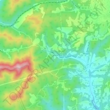
Name: Carlisle topographic map, elevation, terrain.
Average elevation: 593 m
Minimum elevation: 504 m
Maximum elevation: 762 m
Other topographic maps
Click on a map to view its topography, its elevation and its terrain.
Whipple
United States > West Virginia > Fayette County > Scarbro
Whipple, Scarbro, Fayette County, West Virginia, 25917, United States
Average elevation: 578 m