
Savagnier topographic map
Interactive map
Click on the map to display elevation.
Savagnier
Savagnier se situe à environ 6 kilomètres à vol d'oiseau de la ville de Neuchâtel, sur le versant nord de Chaumont, dans la région et ancien district du Val-de-Ruz. Le Grand-Savagnier se trouve à une altitude de 770 mètres, le Petit-Savagnier à 737 mètres.
About this map
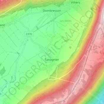
Name: Savagnier topographic map, elevation, terrain.
Location: Savagnier, Val-de-Ruz, Neuchâtel, 2065, Suisse (47.03175 6.93398 47.07511 6.99881)
Average elevation: 860 m
Minimum elevation: 594 m
Maximum elevation: 1,224 m
Other topographic maps
Click on a map to view its topography, its elevation and its terrain.