Geolocate

Condoto topographic map

Click on the map to display elevation.

About this map
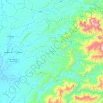
Name: Condoto topographic map, elevation, terrain.

Location: Condoto, San Juan, Chocó, RAP Pacífico, Colombia (4.97959 -76.72470 5.21182 -76.28808)

Average elevation: 320 m

Minimum elevation: 21 m

Maximum elevation: 2,019 m

Other topographic maps

Click on a map to view its topography, its elevation and its terrain.

Acoso

Colombia > Chocó > Condoto

Average elevation: 124 m

Río Puné

Colombia > Chocó > Medio Atrato (Beté) > Pumé

Average elevation: 31 m

Nuquí

Colombia > Chocó > Nuquí

Average elevation: 14 m

Capurganá

Colombia > Chocó > Acandí

Average elevation: 53 m

Plan De Raspadura

Colombia > Chocó > Las Ánimas

Average elevation: 102 m

La lomita

Colombia > Chocó > La Italia

Average elevation: 588 m

Salaquí

Colombia > Chocó > Belén de Bajirá

Average elevation: 75 m

Río Purricha

Colombia > Chocó > Medio Baudó

Average elevation: 64 m

Noanama

Colombia > Chocó > Medio San Juan

Average elevation: 31 m

Gear up for your next adventure:

🧤Waterproof Overmitts - Extreme weather protection for hikers and mountaineers
🥾Hiking Boot Waterproofing Wax - Maintain the lifespan of your leather trekking boots
🔦LED Camping Lanterns - Illumination for reading maps inside your tent at night
🧢Waterproof Hiking Hats - Keep the rain off your face while studying topographic maps
⛺Lightweight Tents - Compact tents for backpacking and trekking

As an Amazon Associate, this site earns from qualifying purchases at no extra cost to you.