Geolocate

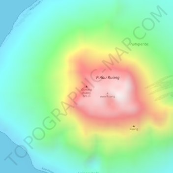
Mount Ruang topographic map

Click on the map to display elevation.

Mount Ruang

Ruang is the southernmost stratovolcano in the Sangihe Islands arc, North Sulawesi, Indonesia. It comprises an island 4 by 5 kilometres (2.5 mi × 3.1 mi) wide. The summit contains a partial lava dome and reaches some 725 metres (2,379 ft) in altitude. From its summit, Klabat's peak in the south, that of Siau to the north, and Ternate to the east can all be seen.

Wikipedia (CC-BY-SA 3.0)

About this map

Name: Mount Ruang topographic map, elevation, terrain.

Location: Mount Ruang, Pumpente, Kepulauan Siau Tagulandang Biaro, North Sulawesi, Indonesia (2.30480 125.36650 2.30490 125.36660)

Average elevation: 288 m

Minimum elevation: 0 m

Maximum elevation: 724 m

Gear up for your next adventure:

💧Hydration Reservoirs - Convenient water bladders for hands-free drinking on the move
👖Hiking Trousers - Durable trousers designed for rough terrain
🕶️Glacier Goggles - Maximum protection for high-altitude snow topography
🎿Telescopic Trekking Poles - Reduces knee strain on steep topographic descents
🥾Men's Waterproof Hiking Boots - Durable footwear with deep lugs for muddy and rocky UK terrains

As an Amazon Associate, this site earns from qualifying purchases at no extra cost to you.