
Uhlerborn topographic map
Interactive map
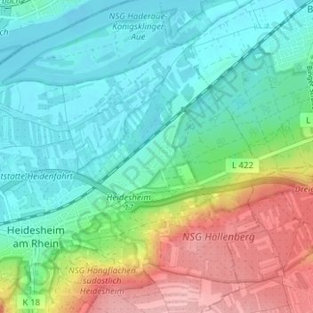
Click on the map to display elevation.
About this map
Name: Uhlerborn topographic map, elevation, terrain.
Average elevation: 121 m
Minimum elevation: 79 m
Maximum elevation: 214 m
Other topographic maps
Click on a map to view its topography, its elevation and its terrain.
Heidesheim am Rhein
Deutschland > Rheinland-Pfalz > Landkreis Mainz-Bingen > Ingelheim am Rhein
Heidesheim am Rhein, Ingelheim am Rhein, Landkreis Mainz-Bingen, Rheinland-Pfalz, 55262, Deutschland
Average elevation: 119 m
Wackernheim
Deutschland > Rheinland-Pfalz > Landkreis Mainz-Bingen > Ingelheim am Rhein
Wackernheim, Ingelheim am Rhein, Landkreis Mainz-Bingen, Rheinland-Pfalz, 55263, Deutschland
Average elevation: 220 m