
Thank you for supporting this site ❤️
Make a donation
Make a donation
Gear up for your next adventure:
As an Amazon Associate, this site earns from qualifying purchases at no extra cost to you.
Silvia topographic map
Click on the map to display elevation.
Thank you for supporting this site ❤️
Make a donation
Make a donation
Gear up for your next adventure:
As an Amazon Associate, this site earns from qualifying purchases at no extra cost to you.
Silvia
西爾維亞是哥倫比亞的城鎮,位於該國西南部,由考卡省負責管轄,距離首府波帕揚59公里,始建於1562年10月23日,面積662平方公里,海拔高度2,800米,2005年人口30,826。
Thank you for supporting this site ❤️
Make a donation
Make a donation
Gear up for your next adventure:
As an Amazon Associate, this site earns from qualifying purchases at no extra cost to you.
About this map
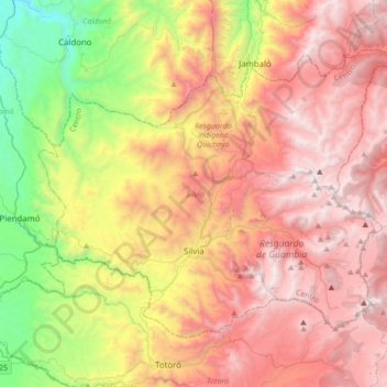
Name: Silvia topographic map, elevation, terrain.
Location: Silvia, Centro, Cauca, RAP Pacífico, 哥伦比亚 / 哥倫比亞 (2.53479 -76.51627 2.78955 -76.17426)
Average elevation: 2,682 m
Minimum elevation: 1,411 m
Maximum elevation: 3,834 m
Thank you for supporting this site ❤️
Make a donation
Make a donation
Gear up for your next adventure:
As an Amazon Associate, this site earns from qualifying purchases at no extra cost to you.