
Hawksbill Mountain topographic map
Interactive map
Click on the map to display elevation.
About this map
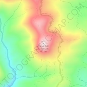
Name: Hawksbill Mountain topographic map, elevation, terrain.
Average elevation: 888 m
Minimum elevation: 625 m
Maximum elevation: 1,202 m
Other topographic maps
Click on a map to view its topography, its elevation and its terrain.
Lake James
United States > North Carolina > Burke County
Lake James is a large reservoir in the mountains of Western North Carolina which straddles the border between Burke and McDowell Counties. It is named for tobacco tycoon and benefactor of Duke University James Buchanan Duke. The lake, with surface elevation of 1200 ft (366 m), lies behind a series of 3 earthen…
Average elevation: 381 m