
鳥島 topographic map
Interactive map
Click on the map to display elevation.
About this map
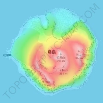
Name: 鳥島 topographic map, elevation, terrain.
Location: 鳥島, 八丈支庁, Tokyo, Kantō, Japon (30.47288 140.28626 30.49601 140.31443)
Average elevation: 87 m
Minimum elevation: 0 m
Maximum elevation: 372 m
Other topographic maps
Click on a map to view its topography, its elevation and its terrain.