
Vortum-Mullem topographic map
Interactive map
Click on the map to display elevation.
About this map
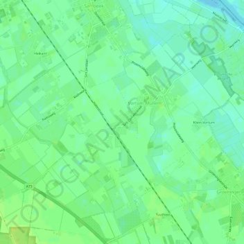
Name: Vortum-Mullem topographic map, elevation, terrain.
Location: Vortum-Mullem, Land van Cuijk, Nederland (51.60307 5.93945 51.63279 5.99937)
Average elevation: 15 m
Minimum elevation: 8 m
Maximum elevation: 22 m
Other topographic maps
Click on a map to view its topography, its elevation and its terrain.
Valkenburg
Nederland > Limburg > Valkenburg
Valkenburg, Limburg, Nederland, 6301, Nederland
Average elevation: 121 m
Den Helder
Nederland > Noord-Holland > Den Helder
Den Helder, Noord-Holland, Nederland
Average elevation: 0 m
Voorschoten
Nederland > Zuid-Holland > Voorschoten
Voorschoten, Zuid-Holland, Nederland
Average elevation: 1 m
Harderwijk
Nederland > Gelderland > Harderwijk
Harderwijk, Gelderland, Nederland
Average elevation: 7 m
Voorthuizen
Voorthuizen, Barneveld, Gelderland, Nederland
Average elevation: 15 m
Aalsmeer
Nederland > Noord-Holland > Aalsmeer
Aalsmeer, Noord-Holland, Nederland
Average elevation: -2 m
Noordwijk
Nederland > Zuid-Holland > Noordwijk
Noordwijk, Zuid-Holland, Nederland
Average elevation: 1 m