
Goring-by-Sea topographic map
Interactive map
Click on the map to display elevation.
About this map
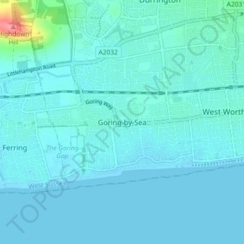
Name: Goring-by-Sea topographic map, elevation, terrain.
Average elevation: 7 m
Minimum elevation: -1 m
Maximum elevation: 78 m
Other topographic maps
Click on a map to view its topography, its elevation and its terrain.
Ferring Rife
United Kingdom > England > West Sussex > Worthing > Ferring
Ferring Rife, Ferring, Goring-by-Sea, Worthing, West Sussex, England, BN12 6QS, United Kingdom
Average elevation: 14 m
Worthing Beach
United Kingdom > England > West Sussex > Worthing > Lancing
Worthing Beach, Lancing, Worthing, West Sussex, England, United Kingdom
Average elevation: 2 m