
Make a donation
Gear up for your next adventure:
As an Amazon Associate, this site earns from qualifying purchases at no extra cost to you.
Ligne des Bambous topographic map
Click on the map to display elevation.
Make a donation
Gear up for your next adventure:
As an Amazon Associate, this site earns from qualifying purchases at no extra cost to you.
Ligne des Bambous
La Ligne des Bambous est un bourg du sud-ouest de l'île de La Réunion situé sur le territoire communal de Saint-Pierre le long d'une route circulant à environ 300 mètres d'altitude.
Make a donation
Gear up for your next adventure:
As an Amazon Associate, this site earns from qualifying purchases at no extra cost to you.
About this map
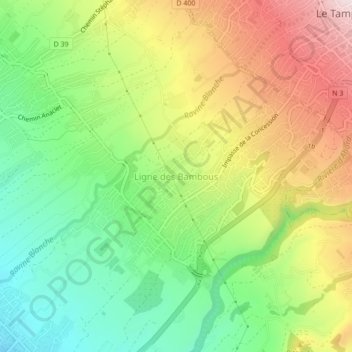
Name: Ligne des Bambous topographic map, elevation, terrain.
Location: Ligne des Bambous, Saint-Pierre, La Réunion, 97432, France (-21.31600 55.47603 -21.27600 55.51603)
Average elevation: 326 m
Minimum elevation: 128 m
Maximum elevation: 588 m
Make a donation
Gear up for your next adventure:
As an Amazon Associate, this site earns from qualifying purchases at no extra cost to you.
Other topographic maps
Click on a map to view its topography, its elevation and its terrain.
Make a donation
Gear up for your next adventure:
As an Amazon Associate, this site earns from qualifying purchases at no extra cost to you.