Geolocate

Kerivallan topographic map

Interactive map

Click on the map to display elevation.

About this map

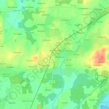
Name: Kerivallan topographic map, elevation, terrain.

Location: Kerivallan, Ploemel, Lorient, Morbihan, Bretagne, France métropolitaine, 56400, France (47.63029 -3.09251 47.67029 -3.05251)

Average elevation: 23 m

Minimum elevation: 0 m

Maximum elevation: 55 m

Other topographic maps

Click on a map to view its topography, its elevation and its terrain.

La Villeneuve

France > Bretagne > Morbihan > Ploemel

La Villeneuve, Ploemel, Lorient, Morbihan, Bretagne, France métropolitaine, 56400, France

Average elevation: 23 m

Lotissement du Golf

France > Bretagne > Morbihan > Ploemel

Lotissement du Golf, Ploemel, Lorient, Morbihan, Bretagne, France métropolitaine, 56400, France

Average elevation: 23 m

Locmiquel

France > Bretagne > Morbihan > Ploemel

Locmiquel, Ploemel, Lorient, Morbihan, Bretagne, France métropolitaine, 56400, France

Average elevation: 24 m

Pax

France > Bretagne > Morbihan > Ploemel > Pax

Pax, Ploemel, Lorient, Morbihan, Bretagne, France métropolitaine, 56400, France

Average elevation: 23 m

Er Grah

France > Bretagne > Morbihan > Ploemel

Er Grah, Ploemel, Lorient, Morbihan, Bretagne, France métropolitaine, 56400, France

Average elevation: 23 m

Kergounio

France > Bretagne > Morbihan > Ploemel

Kergounio, Ploemel, Lorient, Morbihan, Bretagne, France métropolitaine, 56400, France

Average elevation: 24 m