
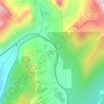
Snoqualmie Pass topographic map
Interactive map
Click on the map to display elevation.
About this map
Name: Snoqualmie Pass topographic map, elevation, terrain.
Average elevation: 1,048 m
Minimum elevation: 662 m
Maximum elevation: 1,698 m
Due to its elevation, Snoqualmie Pass experiences significantly lower temperatures than Seattle, and receives much more precipitation, much of it being snow. Snoqualmie Pass has a humid continental climate (Koppen: Dsb bordering Csb) with cold, very wet and snowy winters, and mild to warm, relatively dry summers.
Other topographic maps
Click on a map to view its topography, its elevation and its terrain.
Seattle
United States > Washington > King County
Seattle, King County, Washington, United States
Average elevation: 40 m
Renton
United States > Washington > King County
Renton, King County, Washington, United States
Average elevation: 83 m
Redmond
United States > Washington > King County
Redmond, King County, Washington, United States
Average elevation: 72 m
Federal Way
United States > Washington > King County
Federal Way, King County, Washington, United States
Average elevation: 81 m
Vashon Island
United States > Washington > King County > Vashon
Vashon Island, Vashon, King County, Washington, 98070, United States
Average elevation: 46 m
Kirkland
United States > Washington > King County
Kirkland, King County, Washington, United States
Average elevation: 58 m
Sammamish
United States > Washington > King County
Sammamish, King County, Washington, United States
Average elevation: 97 m
Auburn
United States > Washington > King County
Auburn, King County, Washington, United States
Average elevation: 88 m
Issaquah
United States > Washington > King County
Issaquah, King County, Washington, United States
Average elevation: 164 m
North Bend
United States > Washington > King County
North Bend, King County, Washington, United States
Average elevation: 160 m
Bellevue
United States > Washington > King County
Bellevue, King County, Washington, United States
Average elevation: 66 m
Enumclaw
United States > Washington > King County
Enumclaw, King County, Washington, 98022, United States
Average elevation: 238 m
Snoqualmie
United States > Washington > King County
Snoqualmie, King County, Washington, 98065, United States
Average elevation: 213 m
Fritz Hedges Waterway Park
United States > Washington > King County > Seattle
Fritz Hedges Waterway Park, 1117, West Campus, University District, Seattle, King County, Washington, 98105, United States
Average elevation: 32 m
Woodinville
United States > Washington > King County
Woodinville, King County, Washington, United States
Average elevation: 73 m
Rhododendron Park
United States > Washington > King County > Kenmore
Rhododendron Park, Moorlands, Kenmore, King County, Washington, United States
Average elevation: 37 m
Foster
United States > Washington > King County > Tukwila
Foster, Tukwila, King County, Washington, 98168, United States
Average elevation: 64 m
Kerry Park
United States > Washington > King County > Seattle
Kerry Park, 211, Queen Anne, Seattle, King County, Washington, 98119, United States
Average elevation: 52 m
Lakeland North
United States > Washington > King County > Lakeland North
Lakeland North, King County, Washington, United States
Average elevation: 113 m
Cottage Lake
United States > Washington > King County
Cottage Lake, King County, Washington, 98077, United States
Average elevation: 112 m
Vashon
United States > Washington > King County
Vashon, King County, Washington, 98070, United States
Average elevation: 50 m
Lakeland South
United States > Washington > King County > Lakeland South
Lakeland South, King County, Washington, United States
Average elevation: 94 m
Union Hill-Novelty Hill
United States > Washington > King County
Union Hill-Novelty Hill, King County, Washington, 98053, United States
Average elevation: 110 m
Ridgecrest
United States > Washington > King County > Shoreline
Ridgecrest, Shoreline, King County, Washington, 98155, United States
Average elevation: 111 m
Bryn Mawr-Skyway
United States > Washington > King County
Bryn Mawr-Skyway, King County, Washington, 98178, United States
Average elevation: 70 m
Kanaskat
United States > Washington > King County
Kanaskat, King County, Washington, 98051, United States
Average elevation: 330 m
Web Mountain
United States > Washington > King County
Web Mountain, King County, Washington, United States
Average elevation: 1,156 m
Baring
United States > Washington > King County
Baring, King County, Washington, United States
Average elevation: 447 m
Lake Morton-Berrydale
United States > Washington > King County
Lake Morton-Berrydale, King County, Washington, United States
Average elevation: 132 m
White Center
United States > Washington > King County
White Center, King County, Washington, 98146, United States
Average elevation: 58 m
Algona
United States > Washington > King County
Algona, King County, Washington, United States
Average elevation: 55 m
Lake Marcel-Stillwater
United States > Washington > King County
Lake Marcel-Stillwater, King County, Washington, United States
Average elevation: 106 m
Lake Forest Park
United States > Washington > King County
Lake Forest Park, King County, Washington, United States
Average elevation: 65 m
Peace Park
United States > Washington > King County > Seattle
Peace Park, West Campus, University District, Seattle, King County, Washington, United States
Average elevation: 39 m
Maple Hills
United States > Washington > King County
Maple Hills, King County, Washington, 98027, United States
Average elevation: 150 m
Hobart
United States > Washington > King County
Hobart, King County, Washington, United States
Average elevation: 235 m
Stevens Pass
United States > Washington > King County
Stevens Pass, King County, Washington, United States
Average elevation: 1,387 m
Madison Park
United States > Washington > King County > Seattle
Madison Park, Seattle, King County, Washington, 98112, United States, Washington Park Arboretum
Average elevation: 40 m
Vasa Park
United States > Washington > King County > Bellevue
Vasa Park, Bellevue, King County, Washington, 99007, United States
Average elevation: 75 m
Shoreline
United States > Washington > King County
Shoreline, King County, Washington, 98155, United States
Average elevation: 99 m
Tukwila
United States > Washington > King County
Tukwila, King County, Washington, United States
Average elevation: 59 m
Benson Hill
United States > Washington > King County > Renton
Benson Hill, Renton, King County, Washington, 98055, United States
Average elevation: 107 m
Finn Hill
United States > Washington > King County > Kirkland
Finn Hill, Kirkland, King County, Washington, 98034, United States
Average elevation: 76 m
Des Moines
United States > Washington > King County
Des Moines, King County, Washington, 98198, United States
Average elevation: 41 m
Puget Sound
United States > Washington > King County
Puget Sound, King County, Washington, United States
Average elevation: 57 m
Cedar Grove
United States > Washington > King County
Cedar Grove, King County, Washington, United States
Average elevation: 139 m
Black Diamond
United States > Washington > King County
Black Diamond, King County, Washington, 98010, United States
Average elevation: 211 m
Discovery Park
United States > Washington > King County > Seattle
Discovery Park, Magnolia, Seattle, King County, Washington, 98199, United States
Average elevation: 28 m
Palmer
United States > Washington > King County
Palmer, King County, Washington, United States
Average elevation: 335 m
Quartz Mountain
United States > Washington > King County
Quartz Mountain, King County, Washington, United States
Average elevation: 943 m