
Le Pioch d'Aussac topographic map
Interactive map
Click on the map to display elevation.
About this map
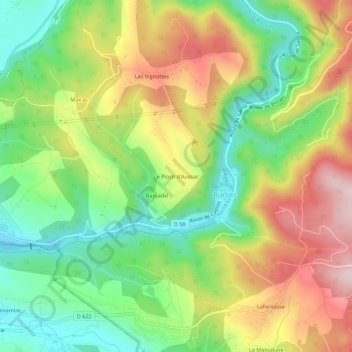
Name: Le Pioch d'Aussac topographic map, elevation, terrain.
Average elevation: 323 m
Minimum elevation: 181 m
Maximum elevation: 504 m
Other topographic maps
Click on a map to view its topography, its elevation and its terrain.
Lafontasse
France > Occitanie > Tarn > Burlats
Lafontasse, Burlats, Castres, Tarn, Occitanie, France métropolitaine, 81100, France
Average elevation: 367 m
Lac du Merle
France > Occitanie > Tarn > Burlats
Lac du Merle, Burlats, Castres, Tarn, Occitanie, France métropolitaine, 81100, France
Average elevation: 633 m
Les Salvages
France > Occitanie > Tarn > Burlats
Les Salvages, Burlats, Castres, Tarn, Occitanie, France métropolitaine, 81100, France
Average elevation: 244 m
Le Lac Bas
France > Occitanie > Tarn > Burlats > Le Lac Bas
Le Lac Bas, Burlats, Castres, Tarn, Occitanie, France métropolitaine, 81100, France
Average elevation: 457 m