
Make a donation
Gear up for your next adventure:
As an Amazon Associate, this site earns from qualifying purchases at no extra cost to you.
Port Lorne topographic map
Click on the map to display elevation.
Make a donation
Gear up for your next adventure:
As an Amazon Associate, this site earns from qualifying purchases at no extra cost to you.
About this map
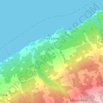
Name: Port Lorne topographic map, elevation, terrain.
Average elevation: 71 m
Minimum elevation: 0 m
Maximum elevation: 237 m
Make a donation
Gear up for your next adventure:
As an Amazon Associate, this site earns from qualifying purchases at no extra cost to you.
Other topographic maps
Click on a map to view its topography, its elevation and its terrain.
North Mountain
Canada > Nova Scotia > Municipality of the County of Annapolis > Port Royal
Average elevation: 134 m
Frasertown
Canada > Nova Scotia > Municipality of the County of Annapolis > Princedale
Average elevation: 138 m
Springfield
Canada > Nova Scotia > Municipality of the County of Annapolis > Springfield
Average elevation: 178 m
Smith Brook
Canada > Nova Scotia > Municipality of the County of Annapolis > Phinneys Cove
Average elevation: 39 m
Make a donation
Gear up for your next adventure:
As an Amazon Associate, this site earns from qualifying purchases at no extra cost to you.
Black Rattle
Canada > Nova Scotia > Municipality of the County of Annapolis > Cloud Lake
Average elevation: 190 m
Milbury Lake
Canada > Nova Scotia > Municipality of the County of Annapolis > Youngs Cove
Average elevation: 163 m
Bobby Hill
Canada > Nova Scotia > Municipality of the County of Annapolis > Paradise
Average elevation: 225 m