
Birchington topographic map
Interactive map
Click on the map to display elevation.
About this map
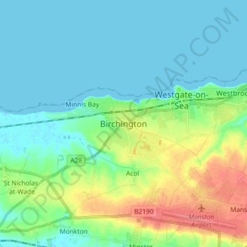
Name: Birchington topographic map, elevation, terrain.
Location: Birchington, Thanet, Kent, England, CT7 9AB, United Kingdom (51.33388 1.26707 51.41388 1.34707)
Average elevation: 15 m
Minimum elevation: -1 m
Maximum elevation: 55 m
Kent trails, hiking, mountain biking, running and outdoor activities
Other topographic maps
Click on a map to view its topography, its elevation and its terrain.
Ramsgate
United Kingdom > England > Kent > Thanet
In 2017 Ramsgate was chosen as one of the first ten Heritage Action Zones (HAZ) by Historic England, with the aim of stimulating economic growth by taking advantage of Ramsgate's historic environment. Part of this project included a Historic Landscape Characterisation Study which assessed and mapped the…
Average elevation: 25 m
Ramsgate
United Kingdom > England > Kent > Thanet
In 2017 Ramsgate was chosen as one of the first ten Heritage Action Zones (HAZ) by Historic England, with the aim of stimulating economic growth using Ramsgate's historic environment as a catalyst. Part of this project included a Historic Landscape Characterisation Study which assessed and mapped the patterns…
Average elevation: 25 m