
Make a donation
Gear up for your next adventure:
As an Amazon Associate, this site earns from qualifying purchases at no extra cost to you.
Fort de Tourneville topographic map
Click on the map to display elevation.
Make a donation
Gear up for your next adventure:
As an Amazon Associate, this site earns from qualifying purchases at no extra cost to you.
About this map
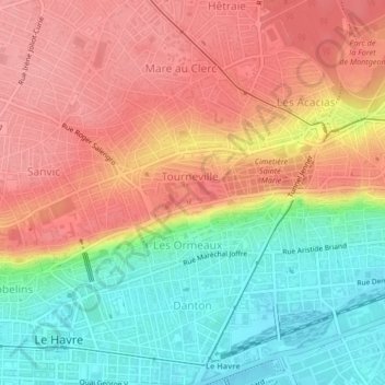
Name: Fort de Tourneville topographic map, elevation, terrain.
Average elevation: 52 m
Minimum elevation: 0 m
Maximum elevation: 93 m
Make a donation
Gear up for your next adventure:
As an Amazon Associate, this site earns from qualifying purchases at no extra cost to you.
Other topographic maps
Click on a map to view its topography, its elevation and its terrain.
Make a donation
Gear up for your next adventure:
As an Amazon Associate, this site earns from qualifying purchases at no extra cost to you.
Le Havre
France > Normandie > Seine-Maritime > Le Havre
Le Havre appartient à l'ensemble géologique du Bassin parisien, formé à l'ère secondaire. Ce dernier se compose de roches sédimentaires. La commune du Havre se compose de deux ensembles naturels séparés par une « falaise morte » ou « côte » : la ville basse, au sud, et la ville haute, au nord. La…
Average elevation: 37 m