
Gunungputri topographic map
Interactive map
Click on the map to display elevation.
About this map
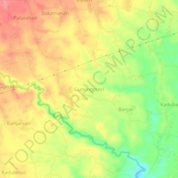
Name: Gunungputri topographic map, elevation, terrain.
Location: Gunungputri, Pandeglang, Banten, Java, 42252, Indonesia (-6.39951 106.06534 -6.35951 106.10534)
Average elevation: 114 m
Minimum elevation: 64 m
Maximum elevation: 150 m
Other topographic maps
Click on a map to view its topography, its elevation and its terrain.