Make a donation
Gear up for your next adventure:
As an Amazon Associate, this site earns from qualifying purchases at no extra cost to you.
Meerut topographic map
Click on the map to display elevation.
Make a donation
Gear up for your next adventure:
As an Amazon Associate, this site earns from qualifying purchases at no extra cost to you.
About this map
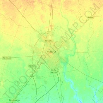
Name: Meerut topographic map, elevation, terrain.
Location: Meerut, Meerut District, Uttar Pradesh, 250003, India (28.82265 77.54810 29.14265 77.86810)
Average elevation: 225 m
Minimum elevation: 214 m
Maximum elevation: 236 m
Make a donation
Gear up for your next adventure:
As an Amazon Associate, this site earns from qualifying purchases at no extra cost to you.
Other topographic maps
Click on a map to view its topography, its elevation and its terrain.
Make a donation
Gear up for your next adventure:
As an Amazon Associate, this site earns from qualifying purchases at no extra cost to you.
Make a donation
Gear up for your next adventure:
As an Amazon Associate, this site earns from qualifying purchases at no extra cost to you.
Make a donation
Gear up for your next adventure:
As an Amazon Associate, this site earns from qualifying purchases at no extra cost to you.
Make a donation
Gear up for your next adventure:
As an Amazon Associate, this site earns from qualifying purchases at no extra cost to you.
Make a donation
Gear up for your next adventure:
As an Amazon Associate, this site earns from qualifying purchases at no extra cost to you.
Make a donation
Gear up for your next adventure:
As an Amazon Associate, this site earns from qualifying purchases at no extra cost to you.
Make a donation
Gear up for your next adventure:
As an Amazon Associate, this site earns from qualifying purchases at no extra cost to you.
Make a donation
Gear up for your next adventure:
As an Amazon Associate, this site earns from qualifying purchases at no extra cost to you.
Mathura District
Mathura is located at 27°17′N 77°25′E / 27.28°N 77.41°E / 27.28; 77.41. It has an average elevation of 174 metres (570 feet). The climate of Mathura is tropical extreme with very hot summers with temperatures rising beyond 44 °C, and cold and foggy winters with the temperature dipping to 5…
Average elevation: 183 m
Make a donation
Gear up for your next adventure:
As an Amazon Associate, this site earns from qualifying purchases at no extra cost to you.
Make a donation
Gear up for your next adventure:
As an Amazon Associate, this site earns from qualifying purchases at no extra cost to you.
Make a donation
Gear up for your next adventure:
As an Amazon Associate, this site earns from qualifying purchases at no extra cost to you.
Make a donation
Gear up for your next adventure:
As an Amazon Associate, this site earns from qualifying purchases at no extra cost to you.
Make a donation
Gear up for your next adventure:
As an Amazon Associate, this site earns from qualifying purchases at no extra cost to you.
Make a donation
Gear up for your next adventure:
As an Amazon Associate, this site earns from qualifying purchases at no extra cost to you.
Make a donation
Gear up for your next adventure:
As an Amazon Associate, this site earns from qualifying purchases at no extra cost to you.
Auraiya
The district of Auraiya lies in the south-western portion of Uttar Pradesh 26.4667°N 79.5167°E and also forms a part of the Kanpur Division. It borders the districts of Kannauj on the north, Etawah on the west, Ramabai Nagar district on the east, and Jalaun to the south. It has an average elevation of 133…
Average elevation: 140 m
Make a donation
Gear up for your next adventure:
As an Amazon Associate, this site earns from qualifying purchases at no extra cost to you.
Make a donation
Gear up for your next adventure:
As an Amazon Associate, this site earns from qualifying purchases at no extra cost to you.
Amethi
District Amethi lies at the latitude 26°9’ north and longitude 81°49’ east at an average elevation of 101 metres(331 feet) from mean sea level. The total geographic area of the districts is about 3063 km2. The surface is generally level, being broken only by ravines in the neighbourhood of the rivers.…
Average elevation: 106 m
Etah
Eta is located at 27.63 ° N 78.67 ° E. [4] It has an average elevation of 170 m (557 ft). The Eisen River flows behind the village Ghazipur Pahor. Etah is a district in the Aligarh division of Uttar Pradesh province, India. It is bounded by Kasganj in the north, Mainpuri and Firozabad in the south,…
Average elevation: 168 m
Make a donation
Gear up for your next adventure:
As an Amazon Associate, this site earns from qualifying purchases at no extra cost to you.
Make a donation
Gear up for your next adventure:
As an Amazon Associate, this site earns from qualifying purchases at no extra cost to you.
Jaunpur
The topography of the district is a flat plain undulating with shallow river valleys. The main permanently flowing rivers are the Gomti and the Sai. The rivers of Jaunpur flow from northwest to southeast and the land slopes in the same direction. Thus, there is a more elevated area in the northwest and a less…
Average elevation: 87 m
Kannauj
Kannauj is located at 27°04′N 79°55′E / 27.07°N 79.92°E / 27.07; 79.92. It has an average elevation of 139 metres (456 feet).
Average elevation: 141 m
Make a donation
Gear up for your next adventure:
As an Amazon Associate, this site earns from qualifying purchases at no extra cost to you.
Mainpuri
The general slope of the country, is from northwest to southeast, and this is the direction in which the rivers run and which is therefore followed in the main by the drainage. There are however, numerous inequalities of surface caused by the greater or less elevation of the river beds and by sand bridges, and…
Average elevation: 156 m
Make a donation
Gear up for your next adventure:
As an Amazon Associate, this site earns from qualifying purchases at no extra cost to you.
Make a donation
Gear up for your next adventure:
As an Amazon Associate, this site earns from qualifying purchases at no extra cost to you.
Make a donation
Gear up for your next adventure:
As an Amazon Associate, this site earns from qualifying purchases at no extra cost to you.
Make a donation
Gear up for your next adventure:
As an Amazon Associate, this site earns from qualifying purchases at no extra cost to you.
Make a donation
Gear up for your next adventure:
As an Amazon Associate, this site earns from qualifying purchases at no extra cost to you.
