
Villarrica topographic map
Interactive map
Click on the map to display elevation.
About this map
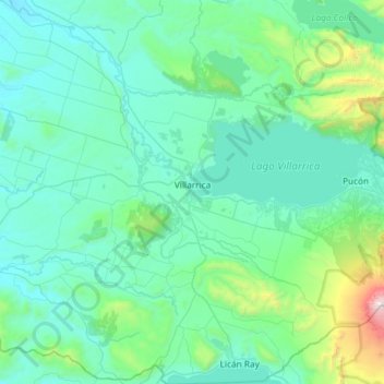
Name: Villarrica topographic map, elevation, terrain.
Location: Villarrica, Provincia de Cautín, Araucanie, 4930611, Chili (-39.51396 -72.43682 -39.05961 -71.90895)
Average elevation: 421 m
Minimum elevation: 116 m
Maximum elevation: 2,831 m
Other topographic maps
Click on a map to view its topography, its elevation and its terrain.
Lautaro
Chili > Araucanie > Provincia de Cautín
Lautaro, Provincia de Cautín, Araucanie, 4860000, Chili
Average elevation: 269 m