
Tárcoles topographic map
Interactive map
Click on the map to display elevation.
About this map
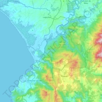
Name: Tárcoles topographic map, elevation, terrain.
Average elevation: 187 m
Minimum elevation: -1 m
Maximum elevation: 1,042 m
Other topographic maps
Click on a map to view its topography, its elevation and its terrain.
Tárcoles
Costa Rica > Provincia Puntarenas > Tárcoles > Tárcoles
Tárcoles, Cantón Garabito, Provincia Puntarenas, 61102, Costa Rica
Average elevation: 49 m