
Altstadt Grossbasel topographic map
Interactive map
Click on the map to display elevation.
About this map
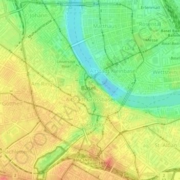
Name: Altstadt Grossbasel topographic map, elevation, terrain.
Location: Altstadt Grossbasel, Basel, Basel-Stadt, 4001, Schweiz (47.55378 7.58400 47.56178 7.59553)
Average elevation: 271 m
Minimum elevation: 243 m
Maximum elevation: 296 m
Other topographic maps
Click on a map to view its topography, its elevation and its terrain.
Kleinbasel
Schweiz > Basel-Stadt > Basel
Kleinbasel, Basel, Basel-Stadt, 4058, Schweiz
Average elevation: 261 m
Grossbasel
Schweiz > Basel-Stadt > Basel
Grossbasel, Basel, Basel-Stadt, 4002, Schweiz
Average elevation: 284 m