
Kelibia topographic map
Interactive map
Click on the map to display elevation.
About this map
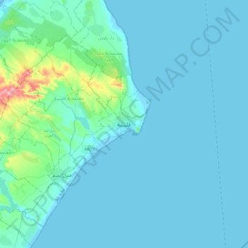
Name: Kelibia topographic map, elevation, terrain.
Location: Kelibia, قليبية الغربية, معتمدية قليبية, Nabeul, 8090, Tunisia (36.68566 10.93357 37.00566 11.25357)
Average elevation: 18 m
Minimum elevation: -3 m
Maximum elevation: 225 m
Other topographic maps
Click on a map to view its topography, its elevation and its terrain.
Kelibia
Tunisia > Nabeul > قليبية الغربية > Kelibia
Kelibia, قليبية الغربية, معتمدية قليبية, Nabeul, 8090, Tunisia
Average elevation: 14 m