
Erkeln topographic map
Interactive map
Click on the map to display elevation.
About this map
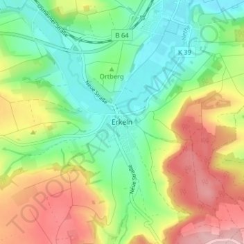
Name: Erkeln topographic map, elevation, terrain.
Location: Erkeln, Brakel, Kreis Höxter, Nordrhein-Westfalen, Deutschland (51.66830 9.20646 51.70830 9.24646)
Average elevation: 187 m
Minimum elevation: 111 m
Maximum elevation: 302 m
Other topographic maps
Click on a map to view its topography, its elevation and its terrain.
Auenhausen
Deutschland > Nordrhein-Westfalen > Kreis Höxter > Brakel
Auenhausen, Brakel, Kreis Höxter, Nordrhein-Westfalen, Deutschland
Average elevation: 271 m
Bellersen
Deutschland > Nordrhein-Westfalen > Kreis Höxter > Brakel
Bellersen, Brakel, Kreis Höxter, Nordrhein-Westfalen, Deutschland
Average elevation: 217 m
Hembsen
Deutschland > Nordrhein-Westfalen > Kreis Höxter > Brakel
Hembsen, Brakel, Kreis Höxter, Nordrhein-Westfalen, Deutschland
Average elevation: 175 m
Istrup
Deutschland > Nordrhein-Westfalen > Kreis Höxter > Brakel
Istrup, Brakel, Kreis Höxter, Nordrhein-Westfalen, Deutschland
Average elevation: 203 m
Rheder
Deutschland > Nordrhein-Westfalen > Kreis Höxter > Brakel
Rheder, Brakel, Kreis Höxter, Nordrhein-Westfalen, Deutschland
Average elevation: 197 m
Bökendorf
Deutschland > Nordrhein-Westfalen > Kreis Höxter > Brakel
Bökendorf, Brakel, Kreis Höxter, Nordrhein-Westfalen, Deutschland
Average elevation: 250 m