
Batumi topographic map
Click on the map to display elevation.
About this map
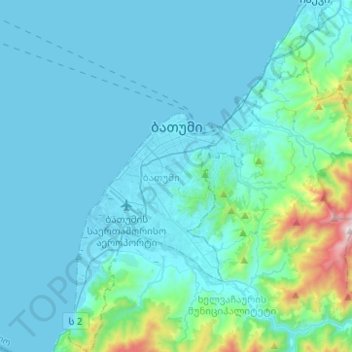
Name: Batumi topographic map, elevation, terrain.
Location: Batumi, Autonomous Republic of Adjara, Georgia (41.53124 41.55949 41.71703 41.74570)
Average elevation: 121 m
Minimum elevation: -2 m
Maximum elevation: 1,176 m
Other topographic maps
Click on a map to view its topography, its elevation and its terrain.
Skhalta
Georgia > Autonomous Republic of Adjara > Khulo Municipality > Khikhadziri
Average elevation: 1,483 m
Murmaneti
Georgia > Autonomous Republic of Adjara > Khelvachauri Municipality
Average elevation: 153 m
Mirveti Waterfall
Georgia > Autonomous Republic of Adjara > Khelvachauri Municipality > Mirveti
Average elevation: 297 m
Mtirala
Georgia > Autonomous Republic of Adjara > Khelvachauri Municipality
Average elevation: 1,000 m
Twin Waterfalls
Georgia > Autonomous Republic of Adjara > Khelvachauri Municipality
Average elevation: 1,079 m
Cold Waterfall
Georgia > Autonomous Republic of Adjara > Khelvachauri Municipality > Sarpi
Average elevation: 101 m
Waterfall at Stone Mining
Georgia > Autonomous Republic of Adjara > Kobuleti Municipality
Average elevation: 484 m
Makhuntseti waterfall
Georgia > Autonomous Republic of Adjara > Keda Municipality > Zeda Makhuntseti
Average elevation: 354 m
Merisi waterfall
Georgia > Autonomous Republic of Adjara > Keda Municipality > Gundauri
Average elevation: 902 m
Kveda Tkhilvana
Georgia > Autonomous Republic of Adjara > Khulo Municipality
Average elevation: 1,635 m