
Make a donation
Gear up for your next adventure:
As an Amazon Associate, this site earns from qualifying purchases at no extra cost to you.
Kitulo National Park topographic map
Click on the map to display elevation.
Make a donation
Gear up for your next adventure:
As an Amazon Associate, this site earns from qualifying purchases at no extra cost to you.
About this map
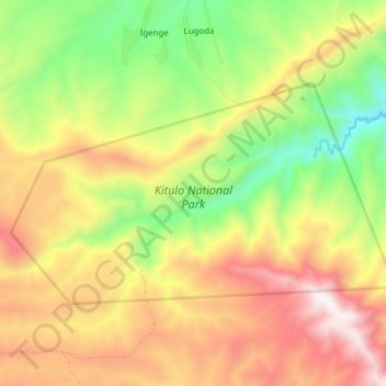
Name: Kitulo National Park topographic map, elevation, terrain.
Average elevation: 2,397 m
Minimum elevation: 1,864 m
Maximum elevation: 2,963 m
Make a donation
Gear up for your next adventure:
As an Amazon Associate, this site earns from qualifying purchases at no extra cost to you.
Other topographic maps
Click on a map to view its topography, its elevation and its terrain.
Njombe
Njombe is a town in southern Tanzania. It is the regional capital of Njombe Region as well as the district headquarter of Njombe Rural District and Njombe Urban District. It is located at nearly 2000 meters of altitude on the eastern edge of the Kipengere Range and has the reputation of being a cold town.
Average elevation: 1,888 m
Make a donation
Gear up for your next adventure:
As an Amazon Associate, this site earns from qualifying purchases at no extra cost to you.