
Welch topographic map
Interactive map
Click on the map to display elevation.
About this map
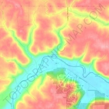
Name: Welch topographic map, elevation, terrain.
Location: Welch, Goodhue County, Minnesota, 55089, United States (44.54830 -92.75853 44.58830 -92.71853)
Average elevation: 277 m
Minimum elevation: 211 m
Maximum elevation: 323 m
Other topographic maps
Click on a map to view its topography, its elevation and its terrain.
Red Wing
United States > Minnesota > Goodhue County
Red Wing, Goodhue County, Minnesota, United States
Average elevation: 263 m
Woodbury WMA
United States > Minnesota > Goodhue County > Zumbrota
Woodbury WMA, 460th Street, Zumbrota, Minneola Township, Goodhue County, Minnesota, 55946, United States
Average elevation: 341 m
Florence Township
United States > Minnesota > Goodhue County
Florence Township, Goodhue County, Minnesota, 55026, United States
Average elevation: 266 m
Pine Island
United States > Minnesota > Goodhue County
Pine Island, Goodhue County, Minnesota, United States
Average elevation: 327 m
Cannon Falls
United States > Minnesota > Goodhue County > Cannon Falls > Cannon Falls
Cannon Falls, Goodhue County, Minnesota, 55009, United States
Average elevation: 268 m