
Rocklin topographic map
Interactive map
Click on the map to display elevation.
About this map
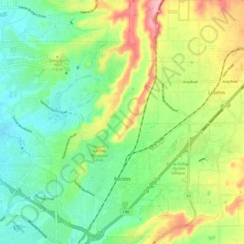
Name: Rocklin topographic map, elevation, terrain.
Location: Rocklin, Placer County, California, United States (38.77032 -121.30001 38.85114 -121.18952)
Average elevation: 95 m
Minimum elevation: 36 m
Maximum elevation: 200 m
Other topographic maps
Click on a map to view its topography, its elevation and its terrain.
Colfax
United States > California > Placer County
Colfax, Placer County, California, United States
Average elevation: 685 m
Carnelian Bay
United States > California > Placer County
Carnelian Bay, Placer County, California, 96148, United States
Average elevation: 1,977 m
Tahoma
United States > California > Placer County
Tahoma, Placer County, California, 96142, United States
Average elevation: 1,923 m
Lincoln
United States > California > Placer County > Lincoln
Lincoln, Placer County, California, 95648, United States
Average elevation: 60 m
Weimar
United States > California > Placer County
Weimar, Placer County, California, 95736, United States
Average elevation: 662 m
Lake Tahoe
United States > California > Placer County
Lake Tahoe, Placer County, California, United States
Average elevation: 2,077 m
Folsom Lake
United States > California > Placer County > Folsom
Folsom Lake, Folsom, Placer County, California, United States
Average elevation: 223 m
Olympic Valley
United States > California > Placer County
Olympic Valley, Placer County, California, 96146, United States
Average elevation: 2,082 m
Oxbow Reservoir
United States > California > Placer County
Oxbow Reservoir, Placer County, California, United States
Average elevation: 604 m
Lincoln
United States > California > Placer County
Lincoln, Placer County, California, United States
Average elevation: 34 m
Blue Canyon
United States > California > Placer County
Blue Canyon, Placer County, California, 95701, United States
Average elevation: 1,452 m
Auburn
United States > California > Placer County
Auburn, Placer County, California, 95603, United States
Average elevation: 380 m
Roseville
United States > California > Placer County
Roseville, Placer County, California, United States
Average elevation: 61 m
Foresthill
United States > California > Placer County
Foresthill, Placer County, California, 95631, United States
Average elevation: 749 m
Applegate
United States > California > Placer County
Applegate, Placer County, California, 95703, United States
Average elevation: 588 m
Gold Run
United States > California > Placer County
Gold Run, Placer County, California, 95717, United States
Average elevation: 930 m
Tahoe City
United States > California > Placer County
Tahoe City, Placer County, California, 96145, United States
Average elevation: 2,005 m