
Make a donation
Gear up for your next adventure:
As an Amazon Associate, this site earns from qualifying purchases at no extra cost to you.
Allo topographic map
Click on the map to display elevation.
Make a donation
Gear up for your next adventure:
As an Amazon Associate, this site earns from qualifying purchases at no extra cost to you.
Allo
La localidad de Allo está situada en la parte occidental de la Comunidad Foral de Navarra, dentro de la comarca de Tierra Estella a una altitud de 432 m s. n. m.. Su término municipal tiene una superficie de 37 km² y limita al sur con Lerín y con Sesma, al norte y oeste con Dicastillo, y al este con Oteiza.
Make a donation
Gear up for your next adventure:
As an Amazon Associate, this site earns from qualifying purchases at no extra cost to you.
About this map
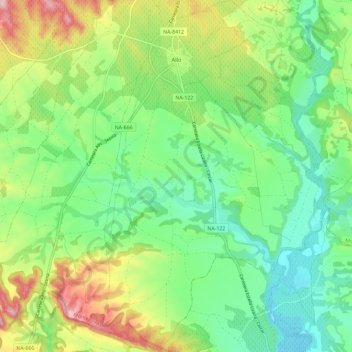
Name: Allo topographic map, elevation, terrain.
Location: Allo, Tierra Estella, España (42.49669 -2.04620 42.58175 -1.97184)
Average elevation: 413 m
Minimum elevation: 338 m
Maximum elevation: 555 m
Make a donation
Gear up for your next adventure:
As an Amazon Associate, this site earns from qualifying purchases at no extra cost to you.
Other topographic maps
Click on a map to view its topography, its elevation and its terrain.
Make a donation
Gear up for your next adventure:
As an Amazon Associate, this site earns from qualifying purchases at no extra cost to you.