
Make a donation
Gear up for your next adventure:
As an Amazon Associate, this site earns from qualifying purchases at no extra cost to you.
Cape Breton Island topographic map
Click on the map to display elevation.
Make a donation
Gear up for your next adventure:
As an Amazon Associate, this site earns from qualifying purchases at no extra cost to you.
Cape Breton Island
The island is characterized by a number of elevations of ancient crystalline and metamorphic rock rising up from the south to the north, and contrasted with eroded lowlands. The bedrock of blocks that developed in different places around the globe, at different times, and then were fused together via tectonics.
Make a donation
Gear up for your next adventure:
As an Amazon Associate, this site earns from qualifying purchases at no extra cost to you.
About this map
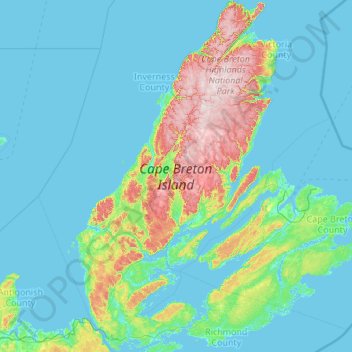
Name: Cape Breton Island topographic map, elevation, terrain.
Location: Cape Breton Island, Nova Scotia, Canada (45.54801 -61.55268 47.04205 -59.78811)
Average elevation: 66 m
Minimum elevation: -3 m
Maximum elevation: 531 m
Make a donation
Gear up for your next adventure:
As an Amazon Associate, this site earns from qualifying purchases at no extra cost to you.
Other topographic maps
Click on a map to view its topography, its elevation and its terrain.
Annapolis Valley
Canada > Nova Scotia > Municipality of the County of Kings > Auburn
Average elevation: 77 m
Make a donation
Gear up for your next adventure:
As an Amazon Associate, this site earns from qualifying purchases at no extra cost to you.
Make a donation
Gear up for your next adventure:
As an Amazon Associate, this site earns from qualifying purchases at no extra cost to you.
Mersey River
Canada > Nova Scotia > Queens County > Kejimkujik National Park of Canada
Average elevation: 93 m
Make a donation
Gear up for your next adventure:
As an Amazon Associate, this site earns from qualifying purchases at no extra cost to you.
Make a donation
Gear up for your next adventure:
As an Amazon Associate, this site earns from qualifying purchases at no extra cost to you.
Cape Split
Canada > Nova Scotia > Queens County > Kejimkujik National Park of Canada
Average elevation: 130 m
Make a donation
Gear up for your next adventure:
As an Amazon Associate, this site earns from qualifying purchases at no extra cost to you.
Chignecto Isthmus
Canada > Nova Scotia > Municipality of the County of Cumberland > Fort Lawrence
Average elevation: 14 m
Make a donation
Gear up for your next adventure:
As an Amazon Associate, this site earns from qualifying purchases at no extra cost to you.
River Philip Centre
Canada > Nova Scotia > Municipality of the County of Cumberland
Average elevation: 85 m
Make a donation
Gear up for your next adventure:
As an Amazon Associate, this site earns from qualifying purchases at no extra cost to you.
Starrs Point
Canada > Nova Scotia > Municipality of the County of Kings > Port Williams
Average elevation: 3 m
Gaspereau Mountain
Canada > Nova Scotia > Municipality of the County of Kings > Forest Hill
Average elevation: 185 m
Make a donation
Gear up for your next adventure:
As an Amazon Associate, this site earns from qualifying purchases at no extra cost to you.
White Hill
Canada > Nova Scotia > Cape Breton Highlands National Park > Cape Breton Highlands National Park
White Hill is a peak in the Cape Breton Highlands and is the highest elevation point in the province of Nova Scotia, Canada.
Average elevation: 488 m
Make a donation
Gear up for your next adventure:
As an Amazon Associate, this site earns from qualifying purchases at no extra cost to you.
Loon Lake Channel
Canada > Nova Scotia > Municipality of the County of Kings > Aylesford Lake
Average elevation: 220 m
Make a donation
Gear up for your next adventure:
As an Amazon Associate, this site earns from qualifying purchases at no extra cost to you.
Victoria Bridge
Canada > Nova Scotia > Cape Breton Regional Municipality > Upper Grand Mira
Average elevation: 17 m
Make a donation
Gear up for your next adventure:
As an Amazon Associate, this site earns from qualifying purchases at no extra cost to you.
Make a donation
Gear up for your next adventure:
As an Amazon Associate, this site earns from qualifying purchases at no extra cost to you.
Eastern Shore District High School Park
Canada > Nova Scotia > Halifax County > Musquodoboit Harbour
Average elevation: 24 m
Gaspereau
Canada > Nova Scotia > Municipality of the County of Kings > Gaspereau
Average elevation: 95 m
Make a donation
Gear up for your next adventure:
As an Amazon Associate, this site earns from qualifying purchases at no extra cost to you.
North Mountain
Canada > Nova Scotia > Municipality of the County of Annapolis > Port Royal
Average elevation: 134 m
Make a donation
Gear up for your next adventure:
As an Amazon Associate, this site earns from qualifying purchases at no extra cost to you.
Salmon River Road
Canada > Nova Scotia > Cape Breton Regional Municipality > Grand Mira North
Average elevation: 18 m
Mullins Point
Canada > Nova Scotia > Municipality of the County of Cumberland > North Wallace
Average elevation: 2 m
Blue Sea Corner
Canada > Nova Scotia > Municipality of the County of Cumberland > Malagash Point
Average elevation: 11 m
The Lookoff
Canada > Nova Scotia > Municipality of Victoria County > Forks Baddeck
Average elevation: 301 m
Make a donation
Gear up for your next adventure:
As an Amazon Associate, this site earns from qualifying purchases at no extra cost to you.
Cape Split
Canada > Nova Scotia > Municipality of the County of Kings > Scots Bay
Average elevation: 6 m
Long Point Provincial Park
Canada > Nova Scotia > Municipality of the County of Inverness > Long Point
Average elevation: 32 m
Make a donation
Gear up for your next adventure:
As an Amazon Associate, this site earns from qualifying purchases at no extra cost to you.
Upper Kempt Head
Canada > Nova Scotia > Municipality of Victoria County > Kempt Head
Average elevation: 20 m
Westchester Valley
Canada > Nova Scotia > Municipality of the County of Cumberland
Average elevation: 194 m
Make a donation
Gear up for your next adventure:
As an Amazon Associate, this site earns from qualifying purchases at no extra cost to you.
Frasertown
Canada > Nova Scotia > Municipality of the County of Annapolis > Princedale
Average elevation: 138 m
Make a donation
Gear up for your next adventure:
As an Amazon Associate, this site earns from qualifying purchases at no extra cost to you.
Upper Glencoe
Canada > Nova Scotia > Municipality of the County of Inverness > Glencoe
Average elevation: 181 m
Make a donation
Gear up for your next adventure:
As an Amazon Associate, this site earns from qualifying purchases at no extra cost to you.
Shingle Lake
Canada > Nova Scotia > Guysborough District Municipality > Forest Hill
Average elevation: 124 m
Roundhill Lakes
Canada > Nova Scotia > Municipality of Victoria County > Cape Breton Highlands National Park
Average elevation: 427 m
Cranberry Lake
Canada > Nova Scotia > Cape Breton Regional Municipality > Enon
Average elevation: 103 m
Make a donation
Gear up for your next adventure:
As an Amazon Associate, this site earns from qualifying purchases at no extra cost to you.
Sporting Mountain
Canada > Nova Scotia > Municipality of the County of Richmond > River Bourgeois
Average elevation: 59 m
Boularderie
Canada > Nova Scotia > Municipality of Victoria County > Ross Ferry
Average elevation: 50 m
Make a donation
Gear up for your next adventure:
As an Amazon Associate, this site earns from qualifying purchases at no extra cost to you.
Meat Cove
Canada > Nova Scotia > Municipality of the County of Inverness > Meat Cove
Average elevation: 117 m
Larry's River
Canada > Nova Scotia > Guysborough District Municipality > Larrys River
Average elevation: 5 m
Centreville
Canada > Nova Scotia > Cape Breton Regional Municipality > Sydney Mines
Average elevation: 12 m
Make a donation
Gear up for your next adventure:
As an Amazon Associate, this site earns from qualifying purchases at no extra cost to you.
Garrets Lake
Canada > Nova Scotia > Municipality of the County of Richmond > Salmon River
Average elevation: 48 m
Make a donation
Gear up for your next adventure:
As an Amazon Associate, this site earns from qualifying purchases at no extra cost to you.
Glasgow Mountain
Canada > Nova Scotia > Municipality of the County of Cumberland > Diligent River
Average elevation: 143 m
Comeau Point
Canada > Nova Scotia > Municipality of the County of Richmond > Alderney Point
Average elevation: 11 m
Lansdowne Lake
Canada > Nova Scotia > Municipality of Pictou County > New Lairg
Average elevation: 160 m
Make a donation
Gear up for your next adventure:
As an Amazon Associate, this site earns from qualifying purchases at no extra cost to you.
Two Rivers
Canada > Nova Scotia > Municipality of the County of Cumberland > Joggins
Average elevation: 52 m
Brown Islands
Canada > Nova Scotia > Cape Breton Regional Municipality > Main-à-Dieu
Average elevation: 0 m
Make a donation
Gear up for your next adventure:
As an Amazon Associate, this site earns from qualifying purchases at no extra cost to you.