Geolocate

Halifax topographic map

Click on the map to display elevation.

About this map

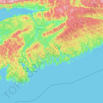
Name: Halifax topographic map, elevation, terrain.

Location: Halifax, Halifax County, Nova Scotia, Canada (44.21437 -63.77780 45.49437 -62.49780)

Average elevation: 60 m

Minimum elevation: -3 m

Maximum elevation: 293 m

Other topographic maps

Click on a map to view its topography, its elevation and its terrain.

Halifax

Canada > Nova Scotia > Halifax County

The coastline is heavily indented, accounting for its length of approximately 400 km (250 mi), with the northern boundary of the municipality usually being between 50–60 km (31–37 mi) inland. The coast is mostly rock with small isolated sand beaches in sheltered bays. The largest coastal features include…

Average elevation: 46 m

Cape Breton Island

Canada > Nova Scotia

The island is characterized by a number of elevations of ancient crystalline and metamorphic rock rising up from the south to the north, and contrasted with eroded lowlands. The bedrock of blocks that developed in different places around the globe, at different times, and then were fused together via tectonics.

Average elevation: 66 m

Halifax Regional Municipality

Canada > Nova Scotia > Halifax County

The coastline is heavily indented, accounting for its length of approximately 400 km (250 mi), with the northern boundary of the municipality usually being between 50–60 km (31–37 mi) inland. The coast is mostly rock with small isolated sand beaches in sheltered bays. The largest coastal features include…

Average elevation: 39 m

Atlantic

Canada > Nova Scotia > Atlantic

Average elevation: 3 m

Lunenburg County

Canada > Nova Scotia

Average elevation: 92 m

Yarmouth

Canada > Nova Scotia > Yarmouth County

Average elevation: 17 m

Eastern Passage

Canada > Nova Scotia > Halifax County

Average elevation: 16 m

Molega Lake

Canada > Nova Scotia > Molega Lake

Average elevation: 88 m

Oat Hill Lake

Canada > Nova Scotia > Halifax County > Dartmouth

Average elevation: 43 m

Town of Bridgewater

Canada > Nova Scotia > Lunenburg County

Bridgewater spans the width of the LaHave River Valley and is dominated by hills that lead down to the river. Elevations range from 5 m above sea level at the river, to nearly 110 m at the southwestern border. Like much of Southern Nova Scotia, the surrounding area is characterized by rolling drumlins formed…

Average elevation: 56 m

Pine Grove

Canada > Nova Scotia > Lunenburg County

Average elevation: 63 m

Lower Sackville

Canada > Nova Scotia > Halifax County

Average elevation: 63 m

Northumberland Strait

Canada > Nova Scotia

Average elevation: 27 m

Halifax County

Canada > Nova Scotia

Average elevation: 37 m

Porters Lake

Canada > Nova Scotia > Halifax County

Average elevation: 60 m

Pictou County

Canada > Nova Scotia

Average elevation: 97 m

Dartmouth

Canada > Nova Scotia > Halifax County

Average elevation: 45 m

Westport

Canada > Nova Scotia > Digby County

Average elevation: 5 m

Oak Island

Canada > Nova Scotia > Martins Point

Average elevation: 3 m

Antigonish

Canada > Nova Scotia > Town of Antigonish

Average elevation: 21 m

Pictou County

Canada > Nova Scotia

Average elevation: 97 m

Dean

Canada > Nova Scotia > Halifax County

Average elevation: 140 m

Membertou First Nation

Canada > Nova Scotia

Average elevation: 112 m

Cumberland County

Canada > Nova Scotia

Average elevation: 66 m

Town of Antigonish

Canada > Nova Scotia

Average elevation: 21 m

Yarmouth County

Canada > Nova Scotia

Average elevation: 28 m

Inverness County

Canada > Nova Scotia

Average elevation: 71 m

Annapolis County

Canada > Nova Scotia

Average elevation: 116 m

Antigonish County

Canada > Nova Scotia

Average elevation: 79 m

Hants County

Canada > Nova Scotia

Average elevation: 76 m

Digby County

Canada > Nova Scotia

Average elevation: 65 m

Kings County

Canada > Nova Scotia

Average elevation: 111 m

Queens County

Canada > Nova Scotia

Average elevation: 75 m

Spondo Lake

Canada > Nova Scotia

Average elevation: 88 m

Town of Pictou

Canada > Nova Scotia

Average elevation: 18 m

Town of Trenton

Canada > Nova Scotia

Average elevation: 45 m

Central Nova

Canada > Nova Scotia

Average elevation: 52 m

Shelburne County

Canada > Nova Scotia

Average elevation: 43 m

Colchester County

Canada > Nova Scotia

Average elevation: 93 m

Guysborough County

Canada > Nova Scotia

Average elevation: 49 m

Cabot Strait

Canada > Nova Scotia

Average elevation: 17 m

Chester

Canada > Nova Scotia > Chester

Average elevation: 16 m

Beaverdam Lake

Canada > Nova Scotia > Shelburne County

Average elevation: 24 m

Bridgewater

Canada > Nova Scotia > Lunenburg County

Bridgewater spans the width of the LaHave River Valley and is dominated by hills that lead down to the river. Elevations range from 5 metres above sea level at the river, to nearly 110 m at the southwestern border. Like much of Southern Nova Scotia, the surrounding area is characterized by rolling drumlins…

Average elevation: 56 m

Lower Rose Bay

Canada > Nova Scotia > Lunenburg County

Average elevation: 23 m

Necum Teuch

Canada > Nova Scotia > Halifax County

Average elevation: 18 m

Bedford

Canada > Nova Scotia > Halifax County

The topography of the area limits the possible locations for football-and-soccer fields. However, there are fields at Basinview Drive Community School, Bedford South School, Charles P. Allen High School, Range Park, Rocky Lake Junior High, and Sunnyside Elementary (Eaglewood location).

Average elevation: 46 m

Bear River

Canada > Nova Scotia > Bear River

Average elevation: 133 m

Truro

Canada > Nova Scotia > Town of Truro

Average elevation: 71 m

Cole Harbour

Canada > Nova Scotia > Cole Harbour

Average elevation: 39 m

Lake Charlotte

Canada > Nova Scotia > Halifax County

Average elevation: 64 m

Beaver Bank

Canada > Nova Scotia > Halifax County

Average elevation: 96 m

Wolfville

Canada > Nova Scotia > Wolfville

Average elevation: 35 m

St. Croix

Canada > Nova Scotia > Hants County

Average elevation: 67 m

Devils Island

Canada > Nova Scotia > Halifax County

Average elevation: 1 m

Pinkneys Point

Canada > Nova Scotia > Yarmouth County

Average elevation: 4 m

Darlings Lake

Canada > Nova Scotia > Yarmouth County

Average elevation: 22 m

Poplar Grove

Canada > Nova Scotia > Hants County

Average elevation: 29 m

Halfmoon Lake

Canada > Nova Scotia > Hants County > Ellershouse

Average elevation: 159 m

New Russell

Canada > Nova Scotia > Lunenburg County

Average elevation: 205 m

Williamswood

Canada > Nova Scotia > Halifax County

Average elevation: 46 m

Walton

Canada > Nova Scotia > Hants County

Average elevation: 36 m

Gear up for your next adventure:

🥤Hydration Bladders - Hands-free hydration systems for backpacks
🔦Head Torches - Hands-free lighting for hiking and camping
🧼Biodegradable Soap - Leave-no-trace hygiene for multi-day mountain treks
🛌Insulated Sleeping Mats - Crucial thermal protection when sleeping on cold, uneven ground
🎒Multi-day Trekking Packs - Large capacity backpacks for wild camping and long-distance trails

As an Amazon Associate, this site earns from qualifying purchases at no extra cost to you.