
City of Lockport topographic map
Interactive map
Click on the map to display elevation.
City of Lockport
Lockport is at the junction of several major truck routes, including NY Route 78 (Transit Road), NY Route 31, NY Route 77 and NY Route 93. It is 17 miles north of Interstate 90 via NY Route 78. The highest point is the bell tower at 452 High Street, with the street itself being the highest street as measured by frontage above the 650 feet elevation.
About this map
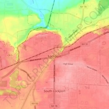
Name: City of Lockport topographic map, elevation, terrain.
Average elevation: 174 m
Minimum elevation: 106 m
Maximum elevation: 203 m
Other topographic maps
Click on a map to view its topography, its elevation and its terrain.
Wurlitzer Park Village
United States > New York > Niagara County > City of North Tonawanda
Average elevation: 178 m
Lockport
United States > New York > Niagara County
Lockport is at the junction of several major truck routes, including NY Route 78 (Transit Road), NY Route 31, NY Route 77 and NY Route 93. It is 17 miles north of Interstate 90 via NY Route 78. The highest point is the bell tower at 452 High Street, with the street itself being the highest street as measured…
Average elevation: 152 m