
Make a donation
Gear up for your next adventure:
As an Amazon Associate, this site earns from qualifying purchases at no extra cost to you.
Rykkinn topographic map
Click on the map to display elevation.
Make a donation
Gear up for your next adventure:
As an Amazon Associate, this site earns from qualifying purchases at no extra cost to you.
About this map
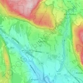
Name: Rykkinn topographic map, elevation, terrain.
Location: Rykkinn, Bærum, Akershus, 1349, Norway (59.90874 10.45531 59.94874 10.49531)
Average elevation: 138 m
Minimum elevation: 21 m
Maximum elevation: 380 m
Make a donation
Gear up for your next adventure:
As an Amazon Associate, this site earns from qualifying purchases at no extra cost to you.
Other topographic maps
Click on a map to view its topography, its elevation and its terrain.
Bærum
The highest point in Bærum is Vidvangshøgda at 60°01′27″N 10°29′02″E / 60.0242329°N 10.4838324°E / 60.0242329; 10.4838324 with an altitude of 552 metres (1,811 ft). The largest lake is Stovivatnet with an area of 0.420 square kilometres (0.162 sq mi) at 59°54′28″N 10°27′03″E…
Average elevation: 203 m
Make a donation
Gear up for your next adventure:
As an Amazon Associate, this site earns from qualifying purchases at no extra cost to you.
Make a donation
Gear up for your next adventure:
As an Amazon Associate, this site earns from qualifying purchases at no extra cost to you.
Make a donation
Gear up for your next adventure:
As an Amazon Associate, this site earns from qualifying purchases at no extra cost to you.
Make a donation
Gear up for your next adventure:
As an Amazon Associate, this site earns from qualifying purchases at no extra cost to you.