
Bagnaia topographic map
Interactive map
Click on the map to display elevation.
About this map
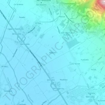
Name: Bagnaia topographic map, elevation, terrain.
Location: Bagnaia, San Giustino, Perugia, Umbria, 06016, Italia (43.50896 12.16055 43.54896 12.20055)
Average elevation: 315 m
Minimum elevation: 288 m
Maximum elevation: 621 m
Other topographic maps
Click on a map to view its topography, its elevation and its terrain.
La Casina
Italia > Umbria > Perugia > San Giustino
La Casina, San Giustino, Perugia, Umbria, 06016, Italia
Average elevation: 761 m
Selci-Lama
Italia > Umbria > Perugia > San Giustino
Selci-Lama, San Giustino, Perugia, Umbria, 06016, Italia
Average elevation: 310 m