
Geiersthal topographic map
Interactive map
Click on the map to display elevation.
About this map
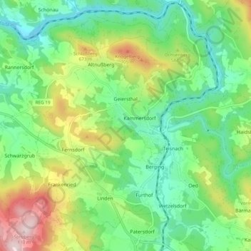
Name: Geiersthal topographic map, elevation, terrain.
Location: Geiersthal, Landkreis Regen, Bayern, Deutschland (49.01090 12.94050 49.07348 13.01603)
Average elevation: 538 m
Minimum elevation: 408 m
Maximum elevation: 803 m
Other topographic maps
Click on a map to view its topography, its elevation and its terrain.
Bayerisch Eisenstein
Deutschland > Bayern > Landkreis Regen
Bayerisch Eisenstein, Landkreis Regen, Bayern, 94252, Deutschland
Average elevation: 919 m
Altwies
Deutschland > Bayern > Landkreis Regen > Unterviechtafell > Altwies
Altwies, Unterviechtafell, Prackenbach, Landkreis Regen, Bayern, 94267, Deutschland
Average elevation: 536 m