
Unterwössen topographic map
Interactive map
Click on the map to display elevation.
About this map
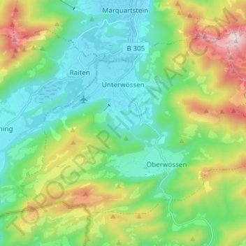
Name: Unterwössen topographic map, elevation, terrain.
Location: Unterwössen, Landkreis Traunstein, Bavaria, 83246, Germany (47.69219 12.40823 47.75334 12.53128)
Average elevation: 888 m
Minimum elevation: 540 m
Maximum elevation: 1,732 m
Other topographic maps
Click on a map to view its topography, its elevation and its terrain.
Höring
Germany > Bavaria > Landkreis Traunstein > Grabenstätt
Höring, Grabenstätt, Landkreis Traunstein, Bavaria, 83355, Germany
Average elevation: 559 m
Tittmoning
Germany > Bavaria > Landkreis Traunstein > Tittmoning > Tittmoning
Tittmoning, Landkreis Traunstein, Bavaria, 84529, Germany
Average elevation: 433 m
Lake Chiemsee
Germany > Bavaria > Landkreis Traunstein > Chiemsee
Lake Chiemsee, Chiemsee, Breitbrunn am Chiemsee (VGem), Landkreis Traunstein, Bavaria, Germany
Average elevation: 527 m