
剣尾山 topographic map
Interactive map
Click on the map to display elevation.
About this map
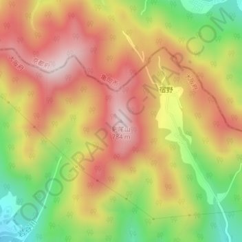
Name: 剣尾山 topographic map, elevation, terrain.
Location: 剣尾山, 能勢町, 豊能郡, 大阪府, 563-0341, 日本 (35.00331 135.40379 35.00341 135.40389)
Average elevation: 554 m
Minimum elevation: 287 m
Maximum elevation: 770 m
剣尾山(けんぴさん)は大阪府豊能郡能勢町宿野に位置する、標高784mの山。北摂山系の主要な山であり、関西百名山、大阪50山の一つである。