
Owmby CP topographic map
Interactive map
Click on the map to display elevation.
About this map
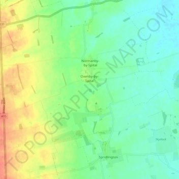
Name: Owmby CP topographic map, elevation, terrain.
Location: Owmby CP, West Lindsey, Lincolnshire, England, United Kingdom (53.36117 -0.54644 53.38054 -0.44532)
Average elevation: 25 m
Minimum elevation: 6 m
Maximum elevation: 59 m
Lincolnshire trails, hiking, mountain biking, running and outdoor activities
Other topographic maps
Click on a map to view its topography, its elevation and its terrain.
Welton Cliff
United Kingdom > England > Lincolnshire > West Lindsey > Welton CP
Average elevation: 53 m
Caen Hill
United Kingdom > England > Lincolnshire > West Lindsey > Great Limber CP
Average elevation: 83 m
Bishopbridge
United Kingdom > England > Lincolnshire > West Lindsey > Osgodby CP
Average elevation: 10 m
Rase Park
United Kingdom > England > Lincolnshire > West Lindsey > Market Rasen
Average elevation: 28 m
Gate Burton
United Kingdom > England > Lincolnshire > West Lindsey > Marton > Gate Burton
Average elevation: 13 m
Scotterthorpe
United Kingdom > England > Lincolnshire > West Lindsey > Scotter CP > Scotterthorpe
Average elevation: 12 m
East Stockwith
United Kingdom > England > Lincolnshire > West Lindsey > East Stockwith
Average elevation: 5 m