
Thank you for supporting this site ❤️
Make a donation
Make a donation
Gear up for your next adventure:
As an Amazon Associate, this site earns from qualifying purchases at no extra cost to you.
Kendallville topographic map
Click on the map to display elevation.
Thank you for supporting this site ❤️
Make a donation
Make a donation
Gear up for your next adventure:
As an Amazon Associate, this site earns from qualifying purchases at no extra cost to you.
About this map
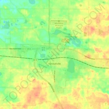
Name: Kendallville topographic map, elevation, terrain.
Location: Kendallville, Noble County, Indiana, 46755, United States (41.41985 -85.30337 41.47639 -85.19706)
Average elevation: 303 m
Minimum elevation: 280 m
Maximum elevation: 324 m
Thank you for supporting this site ❤️
Make a donation
Make a donation
Gear up for your next adventure:
As an Amazon Associate, this site earns from qualifying purchases at no extra cost to you.
Other topographic maps
Click on a map to view its topography, its elevation and its terrain.
Kendallville
United States > Indiana > Noble County > Kendallville > Kendallville
Average elevation: 304 m