
Welden topographic map
Interactive map
Click on the map to display elevation.
About this map
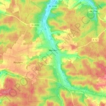
Name: Welden topographic map, elevation, terrain.
Location: Welden, Landkreis Augsburg, Beieren, 86465, Duitsland (48.43085 10.60775 48.48078 10.68958)
Average elevation: 497 m
Minimum elevation: 447 m
Maximum elevation: 535 m
Other topographic maps
Click on a map to view its topography, its elevation and its terrain.
Stauden
Duitsland > Beieren > Landkreis Augsburg
Stauden, Landkreis Augsburg, Beieren, Duitsland
Average elevation: 566 m
Westendorf
Duitsland > Beieren > Landkreis Augsburg
Westendorf, Nordendorf, Landkreis Augsburg, Beieren, 86707, Duitsland
Average elevation: 433 m