Chidamoyo topographic map
Interactive map
Click on the map to display elevation.
About this map
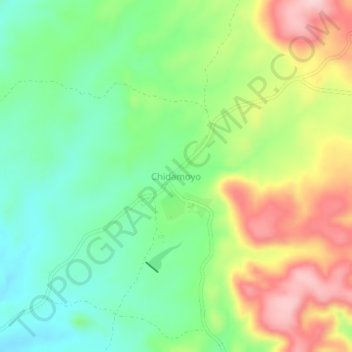
Name: Chidamoyo topographic map, elevation, terrain.
Location: Chidamoyo, Hurungwe, Mashonaland West Province, Zimbabwe (-17.16492 29.16972 -17.12492 29.20972)
Average elevation: 910 m
Minimum elevation: 824 m
Maximum elevation: 1,041 m
Other topographic maps
Click on a map to view its topography, its elevation and its terrain.
Karoi
Zimbabwe > Mashonaland West Province > Hurungwe
Karoi, Hurungwe, Mashonaland West Province, Zimbabwe
Average elevation: 1,274 m
Chirundu
Zimbabwe > Mashonaland West Province > Hurungwe
Chirundu, Hurungwe, Mashonaland West Province, Zimbabwe
Average elevation: 411 m