
Bebedero topographic map
Interactive map
Click on the map to display elevation.
About this map
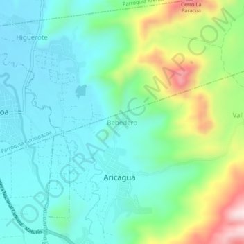
Name: Bebedero topographic map, elevation, terrain.
Location: Bebedero, Estado Sucre, Venezuela (10.22932 -63.91741 10.26932 -63.87741)
Average elevation: 337 m
Minimum elevation: 214 m
Maximum elevation: 677 m
Other topographic maps
Click on a map to view its topography, its elevation and its terrain.
Tronadora
Venezuela > Estado Sucre > Municipio Ribero
Tronadora, Parroquia Cariaco, Municipio Ribero, Estado Sucre, Venezuela
Average elevation: 71 m
Mata Palo
Venezuela > Estado Sucre > Municipio Sucre > Mata Palo
Mata Palo, Parroquia Raúl Leoni, Municipio Sucre, Estado Sucre, Venezuela
Average elevation: 818 m