
Tazrouk topographic map
Interactive map
Click on the map to display elevation.
About this map
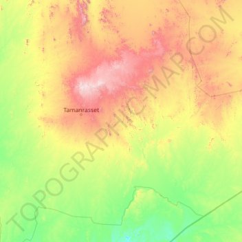
Name: Tazrouk topographic map, elevation, terrain.
Location: Tazrouk, Tazrouk District, Tamanrasset, Algeria (21.04675 5.81136 24.27594 10.27055)
Average elevation: 923 m
Minimum elevation: 474 m
Maximum elevation: 2,715 m
Tazrouk is located in the Hoggar mountains at an altitude of 1,827 metres (5,994 ft). Most of the town is located on the east bank of a wadi that runs past the town from the northwest to the southeast.
Other topographic maps
Click on a map to view its topography, its elevation and its terrain.
Sahara
Algeria > Tamanrasset > Tazrouk District > Tazrouk
Sahara, Tazrouk, Tazrouk District, Tamanrasset, Algeria
Average elevation: 650 m
Oued Tahaggart
Algeria > Tamanrasset > Tazrouk District
Oued Tahaggart, Tazrouk District, Tamanrasset, Algeria
Average elevation: 628 m